
Anúncios
Measuring land accurately is essential for property owners, surveyors, farmers, and developers who need precise calculations for planning, legal, or agricultural purposes.


Whether you’re dividing property, calculating crop yields, installing fencing, or verifying boundaries, understanding how to measure terrain correctly saves time, money, and potential legal disputes. Modern technology has transformed traditional surveying methods, making land measurement accessible to anyone with a smartphone.
Anúncios
From ancient rope stretchers in Egypt to GPS-enabled apps today, the evolution of land measurement reflects humanity’s need for precision and fairness. Let’s explore the methods, tools, and techniques that make measuring terrains both accurate and straightforward in today’s world.
📐 Why Accurate Land Measurement Matters
Precision in land measurement isn’t just about numbers—it directly impacts financial decisions, legal ownership, and development feasibility. An error of just a few meters can translate into thousands of dollars in property value or cause boundary disputes with neighbors that last for years.
Anúncios
For farmers, accurate field measurements determine planting density, irrigation requirements, and harvest projections. Construction professionals rely on precise terrain measurements to calculate material needs, estimate costs, and ensure compliance with zoning regulations. Real estate transactions depend entirely on documented property dimensions that match official records.
Environmental projects also require exact measurements to assess land use, monitor deforestation, or plan conservation areas. Even simple projects like installing a fence or building a shed benefit from knowing exact dimensions beforehand, preventing costly mistakes and material waste.
🛠️ Traditional Methods for Measuring Land
Before digital tools revolutionized surveying, professionals relied on physical instruments that required skill and patience. These methods remain valid today, especially in areas without reliable technology access or for legal documentation requiring certified surveyor involvement.
Tape Measure and Ranging Poles
The simplest approach involves a long measuring tape, ranging poles, and basic geometry. For rectangular plots, measure the length and width, then multiply to find the area. This method works well for small, regularly shaped properties but becomes impractical for larger or irregularly shaped terrains.
Accuracy depends on keeping the tape taut and level, which becomes challenging over uneven ground or long distances. Wind, vegetation, and slopes introduce errors that compound with distance, making this method best suited for plots under half an acre.
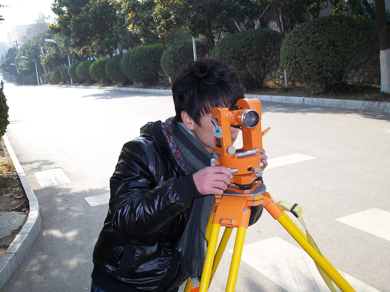
Theodolite and Total Station
Professional surveyors use theodolites to measure horizontal and vertical angles with exceptional precision. When combined with distance measurements, these instruments create detailed terrain maps accounting for elevation changes and irregular boundaries.
Total stations integrate electronic distance measurement with angle readings, storing data digitally for computer analysis. While highly accurate, these tools require training, calibration, and significant investment—typically reserved for commercial surveying operations or legal boundary determinations.
Chain Surveying
This time-tested method uses a measuring chain or tape to divide terrain into triangles, measuring each side to calculate areas using geometric formulas. Surveyors establish a baseline, then measure offsets to create a network of triangles covering the entire property.
Though labor-intensive, chain surveying provides reliable results without expensive equipment. It works particularly well for properties with natural features like trees or rocks serving as reference points, though accuracy decreases on heavily vegetated or steeply sloped land.
📱 Modern GPS Technology for Land Measurement
Smartphone apps have democratized land measurement, putting professional-grade tools in everyone’s pocket. GPS-based measurement applications use satellite positioning to track your movement around a property’s perimeter, automatically calculating area, perimeter, and even slope.
These apps work by recording GPS coordinates as you walk the boundary, then connecting the points to form a polygon. The software applies mathematical formulas to calculate the enclosed area, displaying results in various units like acres, hectares, square meters, or square feet.

Advantages of GPS Measurement Apps
Modern measurement applications offer several compelling benefits over traditional methods. They provide instant results without complex calculations, save measurement data for future reference, and allow sharing via email or cloud storage. Most apps also overlay measurements on satellite imagery, giving visual context to the numbers.
GPS apps excel at measuring irregular shapes that would require extensive triangulation with traditional methods. They handle large properties efficiently—measuring hundreds of acres takes the same effort as measuring a small yard, simply requiring more walking time.
Cost represents another major advantage. A single app, often free or under twenty dollars, replaces thousands of dollars worth of surveying equipment. Updates add new features automatically, and the same device serves countless other purposes beyond land measurement.
Limitations and Accuracy Considerations
Consumer GPS accuracy typically ranges from 3 to 10 meters under ideal conditions, sufficient for general purposes but not for legal boundaries or precision engineering. Factors affecting accuracy include satellite visibility, atmospheric conditions, device quality, and surrounding terrain.
Tall buildings, dense tree canopy, and steep valleys can block GPS signals, causing position drift or gaps in tracking. For critical measurements, walk the perimeter multiple times and average the results, or use a device with differential GPS (DGPS) capability for sub-meter accuracy.
Most smartphone GPS performs better while moving than when stationary, so maintain a steady walking pace around boundaries. Enable high-accuracy mode in your device settings, ensure clear sky visibility, and allow the GPS to acquire sufficient satellites before starting measurements.
🌍 Satellite Imagery and Online Mapping Tools
Web-based mapping platforms offer another approach to land measurement, using satellite and aerial imagery with built-in measurement tools. These services provide a bird’s-eye view perspective, making it easy to identify boundaries, compare properties, and estimate areas without visiting the site.
Google Earth Pro includes professional measurement features, allowing users to draw polygons on satellite images and receive area calculations. The historical imagery feature proves valuable for tracking land use changes over time or verifying property conditions from different seasons.
These tools work exceptionally well for preliminary estimates, planning purposes, or verifying GPS measurements. However, image resolution, capture angle, and processing can introduce distortions, particularly in areas with significant elevation changes or in regions updated less frequently.
🚜 Practical Applications Across Different Industries
Land measurement serves diverse purposes across numerous professions and personal projects. Understanding application-specific requirements helps choose the most appropriate measurement method and accuracy level.
Agriculture and Farming
Farmers measure fields to calculate seed requirements, fertilizer application rates, and irrigation coverage. Precision agriculture depends on knowing exact planted areas to optimize input costs and predict yields accurately. GPS measurement apps help farmers document field boundaries, track crop rotation, and comply with agricultural subsidy programs requiring area verification.
Pasture management benefits from dividing grazing areas into measured paddocks for rotational grazing systems. Knowing precise pasture sizes allows farmers to calculate stocking rates, preventing overgrazing while maximizing land productivity.
Real Estate and Property Development
Property buyers verify advertised land sizes before purchase, protecting against misrepresentation. Developers measure sites to assess development potential, calculate density allowances, and estimate infrastructure costs. Accurate measurements influence property valuations, tax assessments, and insurance premiums.
Land subdivision requires precise measurements to create equal-sized lots or comply with minimum lot size regulations. Even small measurement errors multiply across multiple lots, potentially making entire developments non-compliant with zoning requirements.
Environmental Conservation
Conservation organizations measure protected areas, monitor habitat changes, and document restoration projects. Measuring vegetation clearance, wetland extent, or reforestation areas provides quantifiable data for environmental impact assessments and grant applications.
Wildlife management programs use land measurements to calculate habitat carrying capacity and track territory ranges. Forest inventory projects measure stand areas to estimate timber volumes and carbon sequestration potential.
Construction and Engineering
Site preparation begins with accurate measurements determining excavation volumes, material quantities, and equipment requirements. Civil engineers measure terrain for road layouts, drainage planning, and cut-and-fill calculations that balance earthwork costs.
Residential projects measure lots for placement of structures, septic systems, and setback compliance. Commercial developments require detailed topographic surveys incorporating elevation measurements for grading plans and stormwater management.
📊 Understanding Units and Conversions
Land measurement uses various units depending on location and context. Understanding conversions prevents confusion and ensures accurate communication with different stakeholders.
| Unit | Equivalent | Common Use |
|---|---|---|
| 1 Acre | 43,560 sq ft / 4,047 sq m | US/UK property |
| 1 Hectare | 10,000 sq m / 2.471 acres | International standard |
| 1 Square Mile | 640 acres / 259 hectares | Large tracts |
| 1 Square Meter | 10.764 sq ft | Metric measurements |
Most measurement apps automatically convert between units, but understanding the relationships helps verify results and communicate with professionals using different standards. Regional preferences persist—American real estate uses acres while most other countries prefer hectares.
✅ Step-by-Step Guide to Measuring Your Property
Measuring land accurately requires preparation and systematic approach, regardless of the method chosen. Follow these steps for reliable results:
Preparation Phase
Begin by gathering existing property documents including deeds, surveys, or tax maps showing approximate boundaries. These references help verify your measurements and identify potential discrepancies requiring professional resolution.
Walk the property beforehand to identify boundary markers like stakes, pins, fence lines, or natural features mentioned in property descriptions. Clear vegetation obscuring the boundary to ensure you can follow it accurately during measurement.
Check weather conditions—overcast days often improve GPS accuracy by reducing satellite signal interference, while rain makes terrain difficult to navigate. Charge your devices fully and bring backup power for extended measurements.
Executing the Measurement
Start at a clearly identifiable corner or landmark that you can return to precisely. If using a GPS app, wait until it acquires strong satellite signals before beginning—most apps display signal strength or accuracy estimates.
Walk steadily along the boundary at a consistent pace, keeping the GPS device at the same height and away from your body to minimize signal interference. Mark waypoints at corners or direction changes, noting any obstacles or features affecting the boundary.
Complete the circuit by returning to your starting point, ensuring the measurement polygon closes properly. Most apps indicate closure errors or gaps requiring correction. For irregular properties, walk the perimeter multiple times and compare results.
Verification and Documentation
Cross-check your measurements against property documents, looking for significant discrepancies that might indicate errors or boundary issues. Measure twice if possible, using different methods or devices to confirm consistency.
Save measurements with descriptive names including the date and purpose. Take photos or screenshots showing the measured area overlaid on maps for future reference. Export data in multiple formats to ensure accessibility regardless of software changes.
For important measurements, consider having a professional surveyor verify critical boundaries, especially before construction, property sales, or legal disputes. Professional surveys provide legal documentation that GPS measurements cannot replace for official purposes.
🎯 Tips for Improving Measurement Accuracy
Small adjustments in technique significantly improve measurement reliability, particularly when using consumer GPS devices or apps with inherent accuracy limitations.
- Time your measurement: GPS accuracy often improves during certain times of day when more satellites are visible in your region’s sky
- Enable assistance features: Turn on GLONASS, Galileo, or other satellite systems if your device supports them for additional positioning data
- Walk outside the boundary: Position yourself slightly outside the actual boundary so your body doesn’t block GPS signals toward satellites
- Maintain device orientation: Keep your phone or GPS unit level and pointed in the direction of travel for consistent signal reception
- Avoid metal interference: Metal buildings, vehicles, or even large belt buckles can deflect GPS signals and reduce accuracy
- Take multiple measurements: Repeat the process several times and average the results to minimize random errors
- Calibrate regularly: Some apps offer calibration features that improve accuracy by learning your device’s specific characteristics
⚖️ Legal Considerations and Professional Surveys
While GPS apps and DIY measurements serve many purposes excellently, certain situations require certified professional surveys with legal standing. Understanding when informal measurements suffice versus when professional involvement becomes necessary protects your interests.
Property purchases, sales, or boundary disputes demand licensed surveyor involvement. Courts and title companies recognize professional surveys as authoritative evidence, whereas GPS app measurements carry no legal weight regardless of accuracy.
Building permits often require survey documentation showing setbacks, easements, and property lines. Zoning compliance, subdivision approvals, and mortgage applications may specify professional survey requirements that DIY measurements cannot satisfy.
Professional surveyors carry liability insurance covering errors and provide sealed documents certifying accuracy. Their work establishes legal boundaries in official records, creating the definitive reference for all future property transactions and disputes.
For personal planning, agriculture, general estimation, or preliminary analysis, GPS measurements provide excellent value without professional survey costs. Save professional surveys for situations where legal documentation, maximum accuracy, or official certification are essential.
🌟 Choosing the Right Measurement Approach
Selecting an appropriate measurement method depends on your specific needs, accuracy requirements, budget, and technical comfort level. Match the tool to the task rather than defaulting to either the simplest or most complex option.
For quick estimates of relatively regular properties under five acres, smartphone GPS apps offer unbeatable convenience and sufficient accuracy. They excel at agricultural applications, rough property assessments, and project planning where precision to within a few meters meets requirements.
Larger properties, irregular shapes, or situations requiring repeated measurements over time benefit strongly from GPS technology. The ability to save, share, and overlay measurements on imagery provides context and documentation that traditional methods cannot match.
When legal documentation, maximum precision, or official certification matters, invest in professional surveying services. The cost proves worthwhile for property transactions, construction projects, or any situation where measurement disputes could arise.
Combining methods often delivers optimal results—use GPS apps for preliminary measurements and planning, then engage professionals for final verification when needed. This hybrid approach balances cost, convenience, and accuracy across the project lifecycle.
🔮 The Future of Land Measurement Technology
Emerging technologies promise even more accessible and accurate land measurement capabilities. Drone-based photogrammetry already provides professional-grade surveys at fractions of traditional costs, processing aerial images into precise 3D terrain models.
Augmented reality applications will soon overlay property boundaries onto your visual field through smartphone cameras, making boundary visualization intuitive and immediate. Machine learning algorithms are improving GPS accuracy by predicting and correcting signal interference patterns.
Satellite positioning systems continue expanding—additional satellites and improved signal processing will push consumer GPS accuracy below one meter without special equipment. Integration with property databases may eventually provide instant verification against official records.
Blockchain technology could revolutionize property records, linking GPS measurements directly to immutable ownership records. This convergence of positioning technology and distributed ledgers might streamline property transactions while reducing fraud and boundary disputes.
💡 Making Measurement Part of Property Management
Regular property measurement serves purposes beyond initial surveying. Tracking measurements over time documents changes, supports management decisions, and maintains accurate records as properties evolve.
Seasonal measurements of agricultural fields help optimize crop rotation and track soil productivity changes. Measuring vegetation encroachment along boundaries prevents gradual property line shifts and maintains access routes.
Development planning benefits from maintaining current measurements as properties are improved, subdivided, or repurposed. Historical measurement data supports valuation adjustments, insurance claims, and environmental compliance documentation.
Creating a measurement routine—perhaps annual boundary walks with GPS documentation—builds a valuable property knowledge base. This practice identifies issues early, maintains boundary awareness, and provides documentation proving property stewardship and condition over time.
🎓 Mastering Terrain Measurement Skills
Proficiency in land measurement develops through practice and attention to detail. Start with properties where boundaries are clear and compare your results against known documentation to build confidence and identify common mistakes.
Experiment with different measurement apps and methods to understand their strengths, limitations, and quirks. Each tool behaves slightly differently, and familiarity with multiple options ensures you can adapt to various situations and requirements.
Study basic geometry and surveying principles even if using digital tools—understanding the mathematics behind area calculations helps verify results and troubleshoot unexpected numbers. Recognize when measurements seem wrong and investigate rather than accepting questionable data.
Join online communities or local groups interested in land management, surveying, or property ownership. Sharing experiences and learning from others’ challenges accelerates skill development and exposes you to creative solutions for difficult measurement scenarios.
Whether you’re managing a farm, buying property, planning construction, or simply curious about your land’s dimensions, mastering measurement techniques empowers informed decision-making. Modern technology has made accurate land measurement accessible to everyone willing to learn, transforming what once required specialized expertise into a straightforward process achievable with preparation and practice. ✨